SERVICES - TerraScan 3D - Photogrammetry Service by DRONE and 3D SCAN
Main menu:

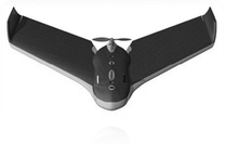
Photogrammetry by drone (UAV) ultra-light provides a high orthomosaic resolution and to generate a 3D model in point cloud colors. The information obtained can be used to calculate volumes, to plan a variety of different types of work and to perform various analysis.
Every deliverable project documentation is completed within the standards of the industry about CAD files or geographic information system (GIS).
- Point cloud files
- Orthomosaic
- Contour line
- Volume calculation
- Etc.

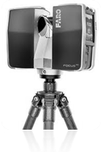
The scanner is used to create a 3D model, an as-built of buildings, industrial equipment and simple or complex structures. The model can be used to analyze the equipment, taking measures to carry out inspections, to planning of works and more. For optimal and safety surveying on special projects, TerraScan 3D creates its own tools in order to adapt to its instruments according to the work environment.
- Point cloud files
- High resolution photos
- Volumes calculation
- Etc.


